
Exploring Death Valley – Photographing Otherworldly Desert Landscapes
- Dec 7, 2025
- 7 min read
Updated: Jan 3
Death Valley National Park lies along the California–Nevada border, about two hours from Las Vegas, in one of the most dramatic desert landscapes in the United States. The hottest place on Earth and the driest region in North America, this vast basin was once a mysterious and intimidating frontier.
Today, its harsh reputation has given way to something entirely different: an otherworldly landscape filled with colourful badlands, rolling sand dunes, rugged mountain ridges, and vast salt flats that seem to stretch endlessly to the horizon.
Whether you’re here for sunrise over Zabriskie Point, the cracked polygon patterns at Badwater Basin (the lowest point in North America) or the delicate curves of Mesquite Flat Sand Dunes, Death Valley offers some of the most unique photographic opportunities in the American Southwest.
While most visitors today come for the scenery, Death Valley’s story was shaped by the struggles and ambitions of early settlers who braved the desert in search of opportunity.
A Brief History of Death Valley
Early settlers and prospectors were drawn here in the mid-1800s by the promise of gold and mineral riches rumoured to lie in the surrounding mountains and canyons. While some deposits were indeed found – most famously borax, which became the region’s most profitable industry – the riches were far less abundant than stories suggested.
Many who attempted to cross the valley underestimated the harsh desert landscape, some getting lost or perishing along the way. One such group in 1849 (known as The Lost '49ers) is often credited with giving the valley its ominous name after a gruelling crossing.
The unforgiving heat, scarce water, and isolation made mining life extremely harsh, giving Death Valley its reputation as one of the toughest places to settle and work in the American West. Today, traces of that era linger in scattered mining ruins and ghost towns like Rhyolite.
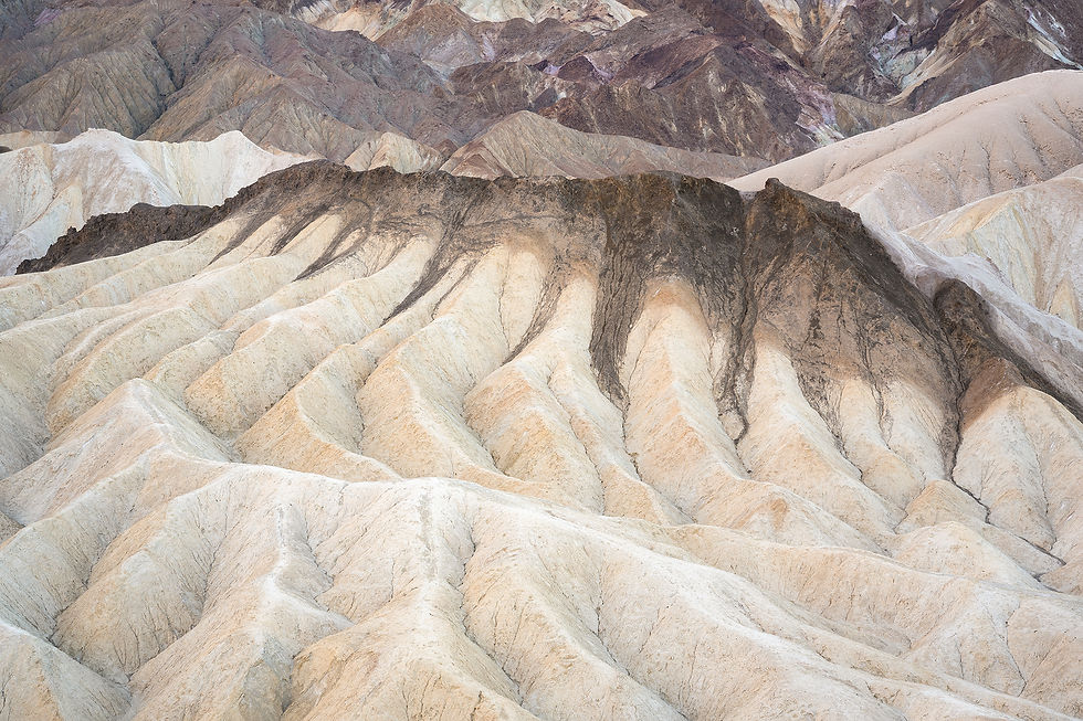
Sunrise at Zabriskie Point
We travelled here during the much cooler and more pleasant winter season to be able to spend plenty of time outdoors and explore the wonders of this unique part of the continent.
Pahrump was our home base – a quiet, unassuming desert town near the edge of the Mojave Desert, not too far from Death Valley. After flying into Las Vegas the night before, we woke up early, made some coffee, and started the drive west. The landscape opened up as we approached the park – desert plains giving way to wavy hills, jagged ridgelines on the horizon, and hints of the badlands glowing under the faint blue-hour light.
Zabriskie Point was our first stop – a popular sunrise location at the gateway to this infamous valley, with sweeping views in every direction. It was an overcast morning and the colours of the badlands were subdued, giving the landscape a calm, atmospheric look and bringing out a range of pastel-like colours.

Early travelers passed through this area in the 19th century, following Furnace Creek Wash from the Amargosa Range mountains down into what became known as Death Valley. One of these pioneers, William Lewis Manly, described the view here as “the most wonderful picture of grand desolation one could ever see”.
Standing there at dawn, with a warm breeze and the valley silent, it’s easy to understand what he meant. Below the viewpoint, Manly Beacon cuts a sharp, unmistakable profile. It’s the triangular golden peak you see in most photographs from Zabriskie Point, named after the same pioneer who crossed this harsh landscape on foot.
Beyond the colourful ridges, pale salt flats stretched across the valley floor.

Take a piece of Death Valley home – view prints here
To the right of it, the Red Cathedral rises like a weather-carved fortress, towering above the maze of the badlands. The sheer scale of this formation was striking – the early light gave its red cliffs an ethereal glow, highlighting the vertical ridges of the massive rock face.

We returned to Zabriskie Point several times over the next few days. The patterns and textures of the colourful hills, shaped over centuries by the powerful forces of nature, overwhelmed with possibilities – offering countless unique compositions in every direction.
Colourful Hills of Artist's Palette
Artist’s Palette sits just south of Furnace Creek, reached by turning onto Artist’s Drive from Badwater Road, north of Devil’s Golf Course.
The drive is an experience in itself – a narrow, winding one-way road that weaves through sculpted badlands, dipping and rising with the terrain. Along the way, the hills shift in colour and texture, blending pale yellows, deep browns, and muted reds.

When you reach Artist’s Palette, you'll feel like you’ve stepped into a different landscape entirely – as if someone brushed colours across the slopes and let them blend in the sun. The hills here get their striking hues from volcanic minerals formed millions of years ago. Reds and yellows from iron, purples from manganese, and soft greens and blues from mica.

Take this landscape home – view prints here
We parked and wandered into the hills, following short paths that lead right into the folds. Up close, the colours appeared richer, almost velvety. Later in the day, when the sun sits lower, tones that can look pale under a bright midday sky gain depth and contrast, and the texture of the terrain becomes more defined.
Photographing it was surprisingly challenging. The colours are subtle, wide-ranging, and constantly shifting with the light. After exploring the slopes from different vantage points, I eventually found a composition that felt right. Artist’s Palette is a place where you could spend hours wandering the hills, with each turn revealing a new vista of colours.
Flooded Flats of Badwater Basin
Badwater Basin sits at 282 feet below sea level and is the lowest point in North America. Looking up from the edge of the basin, you can spot a sign high up on the mountainside marking where "sea level" would be above you. Like most visitors, we came here in search of the famous cracked, polygon-shaped salt patterns stretching across the valley floor. Instead, we were met with something far more unusual.
As we started the walk out onto the salt pan, a shimmer caught my eye – a perfect reflection of the mountains ahead. The basin was flooded, transformed into a shallow lake that mirrored the Panamint Mountains with surreal clarity. The crunchy salt beneath our feet gradually gave way to thin sheets of water stretching toward the horizon.
It was an overcast afternoon, but sunlight eventually broke through the scattered clouds, illuminating the mountain ridges while the water stayed impossibly still.

Yearly rainfall in Death Valley is only about two inches, and we learned from locals that this kind of flooding is extremely rare, happening only after significant storms – this was the first in about a decade. The water came from heavy rainfall brought by Hurricane Hilary, which temporarily resurrected what was once a massive prehistoric lake known as Lake Manly.
We walked the crunchy salt path right up to the water's edge. The scale was hard to grasp – this newly formed lake stretched for miles, yet was only a few inches deep. It wouldn't be long before it evaporated entirely, leaving behind the geometric salt formations this place is known for. We stood there for a while admiring this fleeting moment – a rare wonder in the driest place in North America, and easily one of the most surreal scenes of the trip.
Mesquite Flat Sand Dunes
The Mesquite Flat Sand Dunes near Stovepipe Wells were another must-see stop. As we drove into the area, the scene was striking – a flat desert plain broken by scattered mesquite shrubs, with waves of golden sand rising in the distance and the rugged peaks of the Panamint Mountains towering behind them. It was an impressive juxtaposition.

We wandered out into the dunes on a mild winter afternoon – it was warm, but far from the extreme summer heat this place is known for. Across sandy hills and dry mud plains, we ventured deep into the desert, where it grew quieter the farther we went, with the sand softening the sounds around us. We spotted tiny silhouettes of hikers making their way toward the desert's edge, putting into perspective just how massive the dunes are.
On another visit, while exploring a less-traveled section of the sand, I came across a pattern that resembled scales of a dragon – wind-carved ripples catching the low light. The dunes are full of quaint surprises if you’re willing to roam without a set path.

Wildlife stays hidden during the day, but occasional tracks in the sand tell the story. Rattlesnakes and scorpions can be found here, especially around dawn or dusk, but we didn’t encounter any on our walks. The dunes may not be the tallest in the park, but they’re incredibly photogenic – shifting shapes, clean lines, and constantly changing textures depending on the wind and time of day.
Ghost Town and the Joshua Tree
Our final stop was Rhyolite – a ghost town on the Nevada side of Death Valley, once a booming mining settlement during the early 1900s gold rush. Today, only fragments of that era remain: long streets lined with ruins of old buildings with empty window frames, and rusted debris scattered among the rubble. The place had a quiet, Wild West eeriness to it.
Large vegetation is scarce in and around Death Valley, so we were surprised to spot several Joshua trees just off the gravel road. With its sprawling branches and evergreen leaves, one stood out beautifully against the otherwise muted desert scenery. I stepped carefully across the rocky ground and desert brush, watching for any hidden wildlife as I framed the shot.

In just a few short winter days exploring this California-Nevada desert, I was thoroughly impressed by how much Death Valley had to offer – fascinating landscapes and intriguing history. I can't wait to return and explore more of this beautiful region.
While Death Valley is defined by rugged, minimalistic landscapes, the Southwest takes on a completely new character at higher elevations. Sedona, Arizona offers a very different desert experience – lush greenery and red sandstone buttes replacing Death Valley's barren terrain.
___
If you’re curious about the gear behind my photos, here is my full setup. I keep it simple to travel light, while ensuring my bases are covered for any scene I might encounter.
The links below are affiliate links and I may earn a small commission at no extra cost to you.
As an Amazon Associate I earn from qualifying purchases. Thank you for your support!
Camera & Lenses
Filters
Support & Carry
BLOG | HOME | VIEW PRINTS


